
Driving to the ends of the earth is one good place to find some sense of adventure. When you drive to the end of the road, where the pavement or gravel ends and the trail begins your bound to find something interesting.
Since August of last 2011, right after Seth and I’s successful climb of the Grand, I’d begun planning our summer 2012 adventure. I’d thrown around all sorts of ideas like driving from Urumqi in Xinjiang along the Karakoram highway to Khunjerab Pass at the border of Kazakhstan, the highest paved pass in the world at 15397 feet (4691 meters). Or driving from Shangri-la in Yunnan to Lhasa in Tibet. Eventually we settled on flying into Tibet and visiting base camp at Everest and other sights on the high plateau. BUT self immolations by Tibetan monks resulted in the Chinese government closing the border to foreigners so we opted to visit northern Yunnan which is just south of Tibet and whose inhabitants are all Tibetan. We were headed to a tiny village called Yubeng that is situated in a valley below Meili mountain where we planned to go hiking and do a little backpacking. There are no roads to Yubeng so getting there would be journey itself.
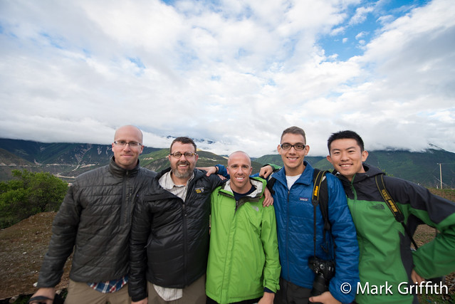
Our final group consisted of myself, Zhang Chao a colleague from the Beijing office who was a fellow outdoorsman who I’d been hiking and backpacking with in China, my brother Josh, my son-in-law Ramon and Seth. Josh and Seth arrived in Beijing and we set out for LiJiang in Yunnan via a flight on Eastern China Airlines. We arrived Wednesday afternoon and caught a taxi to town (a 30 km ride), I was struck by how many women were driving taxis, the majority were women, whereas in Beijing its rare to see a woman taxi driver. We were met in town by Chao who had proceeded us by train. We stayed at a small local hotel just inside the southern gate of the Old City of Lijiang. We rented a room with four beds for 110 rmb (Chao slept on the floor).
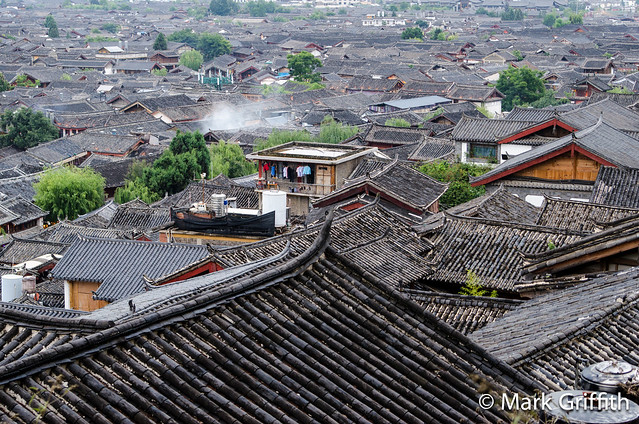
LiJiang is a small city of around 1.5 million, the center attraction of the city is the ancient town where the NaXi minority people live. This old city is quaint maze of narrow stone streets along canals with stone houses with their gray tiled roofs and up turned eaves. Now the houses have been turned into tourist shops, bars and restaurants. Despite the usual factory made trinkets there are some very nice hand made goods that are made on site, such as the woven shawls, silver smiths and the Tibetan bells. You have to pay attention to the quality and craftsmen but you can find some unique items. Â I purchased a large wooden carved placard with a relief of Buddha. Still the most enjoyable time in LiJiang is during the early morning hours when the streets are empty of crowds and the shops are closed up and you can walk in peace and quiet among the local shop keepers that are just making their morning rounds.
The Journey There
Chao had talked with several drivers regarding our transportation from LiJiang to XiDang where the trail to YuBeng began. The route is along the national road G214 which runs all the way from Dali to the Tibetan border. The distance from LiJiang to Feilaisi (small town past Deqin) is 367 km / 228 miles and the town of XiDang is another 32 km / 20 miles from Feilaisi and then its yet another 7 km past XiDang up to the trailhead to Yubeng. Google maps will tell you that this entire route will take you 9 hours but its much closer to twelve. This is due to several factors, one is that despite being a national road its only half complete, the road at our time of traversal was under a seeming constant state of construction. Some parts were paved and others were bumpy rocky sections that would shake your teeth out. Secondly is that there are lots and lots of curves, from a thousand miles up any road appears to be a straight line, but as you zoom in on the route there are interminable zigs and zags winding around long deep ravines. Often these large ravines had partial bridges built directly across but as they were yet unfinished we made the long route on dirt roads deep back into the ravine and around. Lastly is that the road snakes and climbs across several high mountain ranges, ascending from Lijiang at 7500 feet to 10,000 feet at Shangri-la and then up and over a 14,000 foot pass on the way to Feilaisi which itself sits at 11,300 feet above sea level before descending another 4000 feet to XiDang and then climbing back to the trailhead for Yubeng.
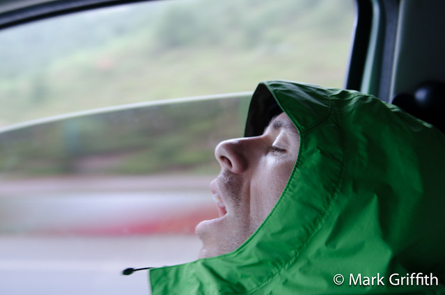
We met our driver ( æœ¨æ‰ / Mù shÄn 139-8704-1980) on Wednesday night and took a look at his Nissan mini-van before settling on a price of 3000 rmb. 1500 for the journey there and 1500 for the return, he’d wait for us 6 days while we were in Yubeng. We left LiJiang Thursday morning at 5 am and settled into the car. There was a bucket seat in the front next to the driver and then two rows of seats one in the middle and one in the back. Our gear was stuffed behind the rear seat, 5 backpacks and a bag of group gear barely fit. The two middle seats really only had enough room for two people and the back seat was a bit cramped made for small kids rather than adults, if you sat back there you had to scrunch in sideways a bit. The initial road out of LiJiang climbs over a first ridge of mountains and is quite windy; this gave way to a bumpy road pot holed with construction. Josh was sitting in a middle seat and just as we hit the bumpy road construction he started complaining of being car sick. We gave him some Dramamine and transferred him to the front seat. He continued to moan and as we pulled up to a high pass he yelled “I am gonna barf” ; I had the driver pull over and he threw up in the gutter. A short while later at 8:15 am we pulled into the town of Shangri-la (renamed recently from Zhongdian to attract tourists) where we stopped for some Baozi for breakfast. Josh sat on the street outside before running to an alley to throw up again. Afterwards he claimed he felt better and he sat in the front seat as we drove on.
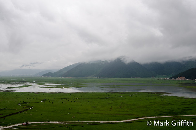
Just north of Shangri-la we stopped at a pull out that over looks Napahai National park, a huge green plain with a shallow lake. Such vast greenness, you could see the herds out on the plains grazing. They wanted to charge us a fee just to go through the stone fence, so I just climbed up on top of the fence for a few photos. We climbed over a 11,300 ft pass out of Shangrila and after several hours further on we crossed over the Mekong River, locally known as Jinsha Jiang (金沙江).  We stopped at another pull out where there was a big bend in the Mekong River. After a few photos we drove on into the town of Benzilan where we ate a restaurant for lunch. The food choices for the rest our journey would be limited to what was available the supply and would be more and more limited. Instead of a menu we were taken to the kitchen where we’re shown a large open fridgerated shelf full of vegetables and meat, we just pointed to what we wanted and they told us how they could prepare it. We also ordered a cup of the yak butter milk tea, which was thick, fatty rich and salty. I could only drink a little before reaching Tibetan tea satiation.
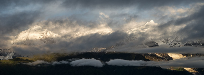
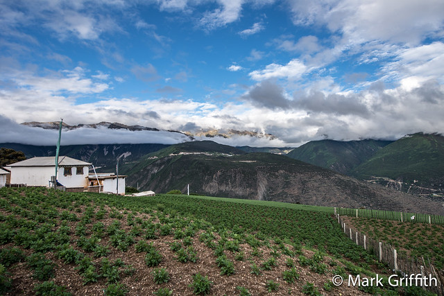
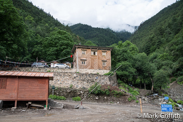
After visiting a 2 rmb public bathroom that required nose plugging and eye aversion to use we got back in the car and headed north. From Benzilan north the road was in good condition and we made good time. About a half hour outside of town we came to the Dongzhulin monastery, destroyed during the Cultural Revolution, the temple was under major construction and we saw men sawing logs with a two-man hand saw. The monastery was quiet and we saw no other tourists. Photographs of the interior are forbidden so we contented ourselves by admiring the large butter sculptures and murals. The butter gave the interior a musky smell and we watched as the monks poured out rice and water for a ceremony. After our short break we headed north again climbing high along the side of the ridge where we crested at a pass at 14100 feet above sea level. We stopped and walked to a look out, we were dizzy, short of breath and had slight head aches from the altitude. From there it was a short drove down through Deqin, around the bend and up to the small town of FeiLaiSi. We arrived at 5:15 pm, 12 hours since we had begun, the town sits at 11,300 feet above sea level, there are numerous hotels that offer views of Meili Shan. We rented a room with 5 beds, two rooms and two baths for 400 rmb. We ate dinner in the adjacent hotel restaurant choosing our 6-7 dishes from the fridgerated shelf which cost us 175 rmb. The boss lady insisted we try the local flower buds they had collected, they were delicious stir fried with egg. We also tried yak meat which was dark, salty and a little tough.
After dinner we walked around town, heading up the road to the small Feilai Temple, where the town gets its name. The temple is set back off the road among fields of wheat and potaoes, the deep Mekong Valley falls away far below. We arrived just after the temple closed and we walked around the exterior and then back down to town to the viewing platform for Meilishan and watched a meager sunrise through the thick clouds and the prayer flags flapping in the wind.
As we drove from LiJiang to FeiLaiSi I was struck by how much the landscape reminded me of the Pacific NorthWest. While the elevation is much much higher the temperature is temperate. In the sections where the mountains catch the rain the hills are covered with deep green pines covered in moss. Wild native rhododendrons were in bloom all over the mountainsides, even at 14,000 ft. This contrasted with the sections left dry by high mountains that stole the rain and were arid and barren like Eastern Washington.
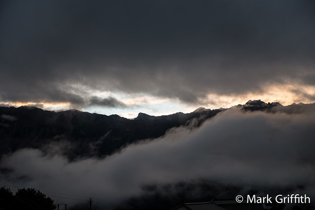
The next morning we woke at 6 am to see the sunrise, things looked to be a bust given the thick cloud cover and we went to a small restaurant for some baozi for breakfast which were more bread than meat. Suddenly across the steeet the sky cleared and the mountains lit up with morning glow. Seth and I dropped our bread and ran across the street to the viewing platform to catch a view of Meilishan which hadn’t shown its face for the past 11 days. After a few photos at 7 am we piled into the van for the last leg of our journey by car, the 60 minute drive to XiDang. A kilometer out of town and we came to a road block and a line of cars and trucks. Workers were drilling in the cliffs and laying it a lattice of steel cables to prevent rockfall. We waited 20 minutes before they finally let us through. We wound back and forth in and out of deep ravines before turning left on a small paved road that made it’s way down toward the valley floor and the Mekong River.
The road dropped over 4000 feet to the village of Beng next to the river where we stopped at a gate ; we surrendered ours passports for registration and purchase our 85 rmb tickets to enter Meili Snow Mountains National Park. From there we crossed the river on a bridge and transitioned to a gravel road as we drove along the ridge line several hundred meters above the river bed. The road winds in and out, often with huge embankments that have been built to prevent erosion. The road is rocky where rains rip down gullies and cross the road to the river. In general our driver seemed to drive at least 20-30% faster on dirt and gravel roads than I would have, though to his credit for the most part everything was ok. Though there was one time on the road to XiDang when I was sitting in the very back and he hit a bump so hard that I hit my head on the ceiling. That wasn’t so fun. We had to slow down for groups of sheep and cows, once I even had to get out of the car and shoo them off the road.
Getting to YuBeng
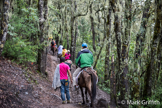
You eventually reach XiDang, which is a very rural village set along a dirt road where the cows roam the streets. We stopped at a small store to ask where the trail head was. They informed us we had to drive another 7 km beyond the village until the road ends at a parking lot. Here you disembark and you can buy water and walk up the road to another staging area where the mule handlers wait and the trail begins. We hired two mules to carry our 4 bags and our bag of group gear over the pass to Yubeng, for insurance sake we hired one more mule to follow us just in case someone pooped out on the trail and they needed a ride. (No one did).  We started out up the muddy trail. You start hiking up through evergreen forests draped in moss with wild white rhododendron blooming along the trail. Prayer flags adorn the high points. There are 2 way stations before the saddle at Yaokou Pass (12300 ft/ 3749 meters) were there is another covered rustic tea-station where you can rest and eat. We had fry bread that tasted like scones, all it needed was some honey butter.
After a rest we made our way down the trail until we stopped in awe when lower Yubeng came into view. As we descended a gentle rain began to fall and we arrived at upper Yubeng (10500 ft above sea leve) where we went directly to MeiDo Inn and booked a couple of rooms that had views of the valley. All told the trip took us 5 hrs 15 minutes (discounting rests) with a total distance of 9.5 km / 5.85 miles and a gain of 4212 vertical feet / 1284 meters.
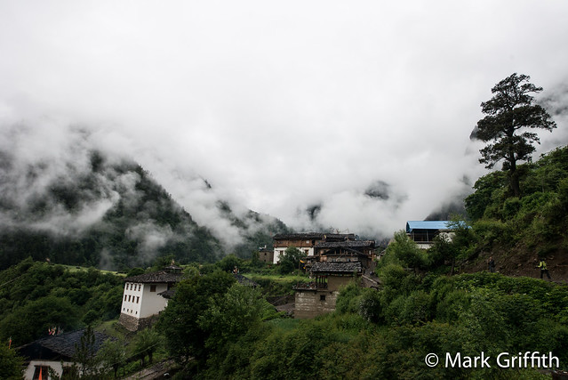
We walked around the town after dinner up the single muddy road, passing a half dozen homes. The street was set with stones and there were stone fences. The pigs, cows and horses seemed to wander freely from field to their pens and their crap was everywhere. Crap and its aroma was a constant presence in the village during our stay. You’d find your self sitting in your room and you’d catch a whiff wafting from you shoes outside the door. We had dinner at at a local restaurant called Tibetan Wine and Dine. The menu was the standard go to the kitchen and pick out what you want. We ordered chicken stew, as Josh was craving some protein. We sat on balcony while we waited for our dinner; the views were amazing up and down the valley. There were two groups ahead of us and our chicken had to be killed, plucked and cut up before cooking in a pressure cooker. We waited well over an hour for our supper.
When dinner finally arrived the fried potatoes were delicious, the egg and tomato yummy as usual but the chicken was a complete let down. Chicken’s in China are butchered by chopping the meat into bite size chunks bone and all, this makes eating a normal chicken a delicate dance of picking the bones out from the meat, but with scrawny, mountain Yubeng chicken that has no meat on their bones it was sucking on bone, gristle and skin. Â Our paltry chicken dish alone cost us 150 rmb. We went to bed tired and full but unhappy about the chicken.
Hiking in Yubeng
Saturday morning we woke around 7:30 (the sky and sunrise was obscured by clouds) and walked back down to Tibetan Wine and Dine for breakfast. We had thick fry bread and a scrambled egg, a little bland but a filling breakfast. By 9:15 we set off for Icy Lake. You walk up the road in upper Yubeng, past the stupa and follow the road through a beautiful valley forest before reaching the Yubeng river where you cross and then follow the trail up through the forest. This is a popular hike and has a well worn trail. Â There are several covered rest areas on the hike. We spent two hours climbing up through huge trees and bamboo before reaching a pass at 3649 m / 11971 ft, you then drop steeply several hundred feet down a rocky trail along a river that has hundreds of mani stone cairn piles. We hiked up along the river to a high meadow where the fateful Sino/Japanese attempt on Meilishan set up base camp. There had been a light rain falling off and on the entire hike, we stopped at several covered structures to have some lunch. We bought a cup of instant Chinese noodles from the caretakers. Somehow the slightly spicy ended up being really spicy and as I was sucking noodles up I inadvertently sucked hot spicy broth up into my nasal cavities; I was wracked with spicy tear inducing fits of coughing for five minutes until I cleared everything out. We filled our water bottles up with hot water the caretaker had been boiling and warmed up a bit by hugging them, happiness is sometimes a hot water bottle.

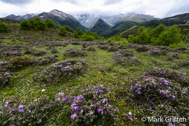
The rain was falling more persistently now so we put on our ponchos and got out our umbrellas (Seth and I carried umbrellas on all our hikes, best piece of gear we brought). We hiked up through a high meadow full of small evergreen trees that have been battered and gnarled by winter snows. There were flowers everywhere, small yellow ones that looked like tall glacier lillies, wild white roses, tiny purple flowered heather (though a bit bigger bush than the Washington variety) and beautiful yellow rhododendron. With the elevation we climbed slowly, ever so slowly to a notch in the ridge at 3856 m / 12650 ft and then drop down a 100 feet to a small pale blue glacier fed lake that sits at the base of MeiLi Shan massif. The rain was falling pretty steady and the top of the mountain was shrouded in cloud and fog. We stopped for a few group photos and then headed back up and down to the meadow; moving was important to stay warm. At 5:15 pm, 8 hours and 13 km / 8 miles after we began we arrived back at Upper Yubeng slightly cold and tired.
For dinner we wanted to try something else, the evening before we had met Monica; her brother and her rent a house they are using as hostel. She is from Singapore and spoke great English. She agreed to cook us some chicken curry. Sadly the chicken was true same as the night before : late and very very scrawny. More skin and bones than meat. They must be mountain chickens that run all day and each one costs you 150 rmb. That was the last chicken we ate in Yubeng.
Sunday we woke to a steady rain and decided to take a day off and just relax and stay in doors. For breakfast we went back to our friends at the Tibetan Wine & Food. We knew we’d be having thick fry bread with fried eggs again, we longed for a bit of honey which would have turned them into scones. When we arrived at the kitchen I noticed some long green peppers on the counter and asked if she had some onions. She said yes so I said I was going to help fix breakfast. I chopped the peppers and onions up with her cleaver and stir fried them in a wok until they were nice and soft we then made some awesome breakfast burritos with egg and grilled veggies on fry bread. Chao’s compliment was : “best breakfast yet”.
The bathrooms at Meido were primitive but they were pretty upscale for country squatters, at least they were porcelain squatters vs. a hole in the ground and they each had a private room with a door. Of course when it rained one of the bathroom’s leaked and you needed an umbrella to stay dry and at night you might have to share it with a toad that hopped in. Josh noted he had a psychological fear of squatters which tended to back him up but after a few days Seth observed they focused you by position and lack of a seat on the business at hand. Perhaps western civilization is doomed because we spend too much time sitting on our toilets with magazines and iPads. Lobsangs Trekker Lodge (139-8879-7053) had western toilets in their standard rooms but their squatter bathrooms for the common rooms were awful, maybe a not so subtle hint to encourage you to book their standard rooms : they were three slots in an open room with no privacy or running water. You did your business right next to your neighbor and in plain view of everyone else’s previous business.
Our showers at Meido were solar heated, which meant for us luke warm given the amount of sun we saw. There were two private wooden room with nails on the wall to hang your clothes and a cement floor with a single drain, one of which seemed to back up. Shampoo you could buy from a local store. Ramon and I had forgotten towels so we were delighted to find one little store had the super teeny Chinese hand towels for sale, but they were better than reusing Seth’s camp towel. The Meido Inn had just opened recently and was run by couple of Chinese partners. Our resident partner was a girl from ShenZhen who had quit her job at QQ and had been there a week and seemed over whelmed and burdened by being both the boss, the cleaner and wood cutter. She did have a pet monkey on a leash to keep her company though. Â Ironically in China where one of the major surpluses is labor in Yubeng there isn’t enough people and so she was having to do multiple jobs.
We sat around editing photos, reading or playing games on the iPads. We set up my MacBook in an empty back room that was quiet and dark and watched The Grey. That evening we had dinner with fresh pork and peppers at Lobsangs (they kill a pig once a week in the village), that dish alone cost 45 rmb or the US equivilant of $28 (not through strict conversion of rmb to USD but in terms of Chinese salaries and costs). We inquired about the hike to Holy Lake and were told it was too steep to hire pack animals (joy) and we should have a guide, most people don’t hike there so they trail wasn’t as obvious. We hired a guide for 225 rmb who would lead us to the meadow where we would camp.
Cell service in Meido only works on China mobile and only during daylight hours when it isn’t storming too severely. (I still can’t figure out the only day part) So Saturday we had Zhang Chao call his girlfriend on the Meido’s bosses phone to email Stac and tell her that Mark and Ramon were ok and have her get a message to Amy that Seth was ok. That evening we got a text back on the bosses phone : “checking account problems need help” but by then there was no cell service. The next morning a new message went out from me : “if there is a problem have bank or Stacey call me” a few hours later the reply came back relayed via Zhang Chao’s girlfriend texting an email she’d received from Stac : “Stac cell number XXX XXXX XXXX” ugh, I guess I would have to call.
So I put on my shoes grabbed an umbrella and made my way up the road to Monica’s. No one was home so I waited until she came walking up the road in her hat, coat and rubber wellies (smart shoe choice given the rain and muddy roads). I asked her if I could borrow her phone to call Hong Kong. She said sure, he just had to change her phone to her Singspore sim card and that I would have to walk up the road to the Stupa where the service was better. Off I went up the muddy road until I was standing on a rock pile next to the pig pen mud hole below the white stupa and a green wheat field. After 4 or 5 failed dials I finally figured out how to dial Stac’s Hong Kong cell. Worried something was wrong I was relieved to hear that all was well and things were just very expensive in HK and they were worried about having enough money. I said “I’m standing on a rock pile in pig crap with rain falling all around me”. Stac : “yes but you chose that,” true I explained but hers were first world problems I am in the third world. I suggested she make a daily budget and she’d be fine. We chatted for a few moments and then I signed off.
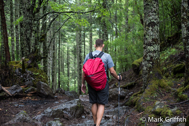
Since pack mules were out we’d be carrying our own packs, that evening we repacked all our bags, distributing group gear, paring down to the essentials for an overnighter at Holy Lake. The fact we’d all brought pack covers made the hike in the rain possible. Our guide met us at 8:30 am and helped carry our now huge group bag gear full of everything we’d be leaving behind. We tromped down the muddy trail in the rain, crossed the raging river that was swollen from two days of non stop rain and then humped up some stone steps to Lower Yubeng where we dropped our stay behind bags and gear at Sacred Waterfall Inn. Then we set off across the river again and immediately the trail starts up. You could tell the trail doesn’t get much traffic because there was very little garbage on the trail. I was disgusted and angered by the sheer amount of trash that people leave on the trails and in the camp sites. There seems to be no sense of cleaning up after themselves; packing out what they pack in, leave no trace is “throw your crap on the ground”. I’ve seen this same thing in the US as well, there have been times when I’ve carried a full bag of Mountain House garbage out of campsites, but its so much more pervasive in China. I think much of this comes from a lack of education (remember in the 1970’s in the US when this message was pushed hard : “Give a hoot, don’t pollute”) and the fact that in major cities if you throw something on the ground there is such an excess of labor that there are a plethora of street cleaners who will pick up the trash within the hour.
The trails starts off steep with short switchbacks taking you steadily higher. There is only one crossroads on the trail around 10,800 feet after about 30 minutes of strong hiking. Going up at the cross you just keep going up, coming down instead of taking the switchback you keep going straight down. This was the only choice in the faint but obvious trail. Thus a guide wasn’t really necessary for route finding, but he did agree to carry one of our packs. I volunteered mine and I hiked the first 30 minutes in guilt until I switched with Seth. Every 30 minutes we rotated between Seth, Josh and myself. We started in the rain and it continued all day. By my 3rd rotation without a pack I was looking forward to putting Seth’s pack on, hiking with an umbrella and a long sleeve shirt and shorts I was getting chilled, rain and the dropping temperatures with the elevation gain. By the 5th rotation I just kept the pack on for warmth and kept climbing up. After 3500 vertical feet the trail starts to level off a bit and not be quite as steep. Above you another 2000 feet or more looms a massive forest covered hill. We crested a small knob where there were prayer flags and views down into the valley.
By this time even with Seth’s pack on I was chilled to the bone and my hands were starting to numb with cold and my shirt was soaked with sweat. I stopped under a tree and stripped off my shirt, put on my Mammut soft shell and put my plastic purple poncho on over, more to retain heat than to keep off the rain since the umbrella did a pretty good job of that. Feeling much better Seth shouldered his pack and we carried on. From here we started to gradually traverse upwards on the side of the hill through a beautiful set of rhododendron bushes among large evergreens, it was almost as if you were hiking in a tended garden. Quickly we transitioned above treeline and we were on a fairly flat trail that traverses a steep hillside covered in small alpine shrubs and wildflowers.
As we made our way around the hill through slight fog a flat meadow came into view where there sat the low rock walls of an abandoned shelter. We descend down to the meadow. We had been hiking for 5.5 hrs in the rain and it was coming down pretty hard when we arrived at the meadow. We’d only covered 4.4 km / 2.75 miles and gained around 4400 vertical feet, our camp was at 13,671 feet. By this time I was warm but Ramon and Josh were very wet and cold. The first order of business was getting some shelter from the rain. The shelter had four rock walls about 3 feet high, on one side the wall was built up to point of 6 feet for a roof; there was a center pole and beam on one side of the shelter and on one quarter there was some of the large Tibetan wooden shingles (3-4 feet in length and 4-8 inches wide) that are the common way to roof buildings. There were numerous other shingles spread on ground inside to make a platform for sleeping; there was also a large number scattered on the ground outside the shelter, probably knocked down by snow. There was also a bit of old plastic tangled up in the rafters so we re-arranged that a bit, and then we started throwing shingles over the roof beams in the one corner. By stacking the shingles two deep you can pretty much prevent rain from leaking through. On top of this we then pitched Seth’s Beta-Mid shelter for an extra layer. To finish things off in one corner of our shelter we propped up Seth and I’s umbrella, this allowed us get almost 1/2 covered and set up two tents a 3 man Big Agnes for Josh, Zhang Chao and myself and Seth and Ramon in the other Big Agnes 2 man tent.

Josh and Ramon changed and got into their tents and sleeping bags to warm up and I started boiling water for our Mountain House dinners that Seth had brought with him from America. By 7:30 pm most of them were fed and in bed asleep, Seth and I waited a bit longer to eat and as usual beef stroganoff never tasted so good. Afterwards I read until 10:30 pm when I feel into a not so restful sleep. This was the highest I’d ever camped before and while I didn’t have a headache and wasn’t uncomfortable I felt and slept restlessly. I woke several times in the night, the last tie at 3:30 am; I must have read for an hour while I listened to the hard falling rain. We went to bed with the rain falling and woke up to the same, it had now been raining for three days straight. It never stopped raining, it only would abate and not rain hard. We boiled some water for breakfast and each had a single packet of maple and brown sugar oatmeal (I should have brought two per person).
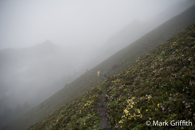
We grabbed our umbrella’s and cameras, left everything else and set off for Holy Lake, which was a short 45 minute hike around 1.2 km / .75 miles with an elevation gain of 237 m / 780 feet. The trail was recently free’d from snow and wild flowers were desperately attempting to flower and were bright spots among the moss and high alpine grass. Surprisingly there was still small low rhodedederon bushes full of pink blossoms covering the hillsides. The lake sits at 14,200 feet in a small cirque and is larger than Icy Lake. When our guide had left us at the shelter the day before he had warned us : “Don’t even put your toes in the water, if you do the gods will kill you”. The falling rain and cold temperatures offered no temptation of taking a dip, we set up the camera under an umbrella for a group photo and then Josh, Chao and Ramon set off for camp while Seth and I went at a more leisurely pace, taking photos as we went.
Back at the shelter we broke camp, stuffing wet tents into bags and stuffing bags into our pack. Again Chao, Ramon and Josh set off first out of camp on a quicker pace. Everyone was a little tired of the rain, some more than others. As Seth and I chatted while we hiked down we commented on the very distinct zones that were set across the elevation bands on the mountain. We camped in the (1) high alpine zone above tree line above 13500 feet characterized by small ferns, heather, high alpine rhodies, alpine flowers and moss. (2) The Conifer – Rhodie Garden zone, below 13,500 feet this was very narrow with only a 500 vertical foot band, the rhodies grew so thick you would think they had been planted and were interspersed with large evergreens. (3) Giant rhodie forest, this was a rather large zone 750-1000 vertical feet of huge rhodie trees that were 25-30 feet tall, these were also interspersed with large conifers. (4). Bamboo zone which was rather larger, 1000-1500 vertical feet with clusters of skinny 3/4 to inch thick bamboo shooting heavenward and finally (5) the largest zone with “normal forest”, a mixed conifer deciduous trees to valley floor scattered with wild rhododendron bushes.
After we left the Conifer-Rhodie Garden the trail got steeper and with rain falling for two days straight the trail was muddy, slick and treacherous. Without poles things would have been very very difficult. Â There are different gaits when your hiking based on whether your heading up or down and how wet and slippery the trail was. Going down in the mud with the trail as steep as it was you had to maintain constant tension in all your leg muscles; there was never any relaxation that comes when your foot rests comfortable secure on the trail. It was like descending on ice, you never knew when your foot would slide out from underneath you. We had a bet that the first person to fall was the last in the shower, Seth and I slipped several times but managed to never go all the way butt down, Josh went down at least three times. As we entered the final forest section the rain kept falling but the when you hike in the rain under canopy you don’t get the normal even pitter patter of raindrops, you get big intermittent rain bombs dripping from the leaves after the quantity of water and gravity overcome water’s natural weak covalent bonds. Amazingly for 5 minutes on the trail the rain did in fact entirely stop and we had 3-4 minutes of sunshine. We stopped to hold our faces to the sun and bask in its short lived glory. Near the end of the trail my legs were shaking from the constant strain of trying not to fall and the relentless down; the trail made Mailbox peak look walk in the woods. Finally we arrived at the bottom, crossed the river and thankfully only had a short walk to our hostel.
We spread gear on the porch under the balcony and in our room with five beds. Rooms and bathrooms in lower Yubeng are decidedly more rustic, there were no electric plugs and only a single bare bulb lit the room. By now we were all beginning to smell a little funky, it had been several days since our last shower. In our very close quarters in tents the night before Seth was talking about the Dirtbag Diary episode about the 5 types of BO. They are :
- Type 1 : People who say they can’t bike to work because they will arrive at work “all sweaty”. Sweat dries and in a few hours it’s gone.
- Type 2 : Beginning of smell, when you lift your arm and sniff there is a presence, you don’t want it on a first date but it is far from offensive.
- Type 3 : Real BO, smells bad enough to offend other people and they definitely notice, they are not angry at you, but they would rather not smell you and but they don’t appreciate you or want to sit by you.
- Type 4 : This is BO not coming just from arm pits but from feet and the lower hemisphere, all parts coming together in one force. Where people just notice type 3 and have a reaction to it, with type 4 they are genuinely offended. When you walk between tables at a burrito joint and people make angry faces. At first they can’t believe it and then they decide to judge you.
- Type 5 : Type 5 is so bad it offends even yourself, you dry heave a little after accidentally lifting your arm. You sit down at a pit toilet in a national park and the first thing you notice is not the gallons of human waste wafting up from below you but the smell coming from multiple regions of your body.
We had definitely reached type 4 and despite the lack of even warm water we lined up for a cold shower and attempted to wash some of the sweat off our bodies and the mud off our shoes. That night we ate a hearty bowl of noodles at the hostel’s kitchen before settling down for the night.
Leaving Yubeng
The next morning my legs still ached from their relentless pounding the day before. I joked with Seth that our hike to Holy Lake had been like a Green Rainier, hiking to the same height as Rainier’s summit but without the snow. Seth’s retort was that he had been calling it  The Chinese Water torture because of all of the rain. We ordered a set of mules to carry not only our gear out but to carry us to the top of Yakou Pass. First we had to carry our bags across the river and to the stable area where we met our porters. They did a lucky draw for who got assigned what horses and we loaded up our bags and climbed on our horses, donkeys or in my case pony. We dwarfed in size the animals we rode upon, Ramon looked like he could straddle the donkey he was riding, but to their credit they carried us the entire 3 km and 2400 vertical feet, they were tough little horses. Riding was definitely less exertion than hiking yourself, but your trading off pain in your butt from sitting on small wooden Tibetan saddle vs humping up hill. At the top of the pass we disembarked and after letting our legs recover we headed down the muddy trail to the trail head at XiDang. I was ready to be down and out and I hammered it pretty hard and fast back down. By the end I didn’t care about the mud only where I could step to avoid from slipping. At times I was boot skiing down the trail in the thick slick mud. I arrived around 12:15 to find our driver waiting for us and the others arrived within a half hour. We unloaded our bags from the mules, paid the porters and lugged our bags to the lower parking lot where we stowed gear and washed our legs and feet in the cold mountain stream. Josh and I left our boots on the steps of the entrance building and we all climbed in the car. A short 90 minutes later we were in Feilaisi where we stopped and had lunch.
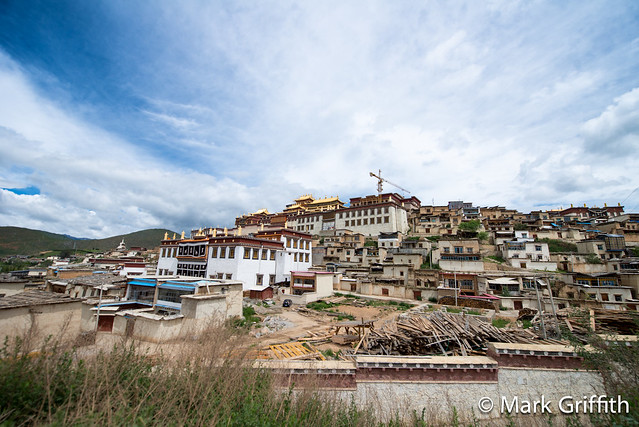
Thankfully we had an extra day before our flight back and we only had to make it to Shangri-la, a drive of four hours. I sat in the back and listened to 4 hours of pod casts that I hadn’t touched (thank goodness). We were all waiting our return to civilization and real toilets and bathrooms. When you go backpacking your body has this psychological affect on your lower bowels, knowing you’ll be far away from comfortable bathrooms your body goes into lock down mode. Things back up and eventually at some point things will have to flow and you’ll just have to go no matter where you are. We’d left for Holy Lake on Monday morning and spent Monday night camped in the high meadow, Tuesday night we spent in Lower Yubeng with pit toilets and Wednesday night we arrived in Shangri-la. Thursday morning in Shangri-la in a hotel with western toilets and things still weren’t flowing. My body was still in lockdown mode and I was wondering how long it was going to take to wake things up. That morning we toured the Songzanlin Monastery (Ganden Sumtseling Monastery), this impressive set of buildings was first constructed in 1679 and then rebuilt after extensive damage during the Cultural Revolution.  Somewhere along the way Seth started feeling nauseous and after we exited the main monastery he sat on the steps for a few moments and then wandered up behind a fence and a tree on a hill where he vented his stomach on the ground.
For lunch we were craving something western with real protein, I was sick of pork with peppers and stir friend egg and tomatoes.  We searched for a KFC (way more popular in China than McDonalds) but settled on a KFC copycat : Dicos. The Fried chicken and chicken sandwiches tasted delicious. Early afternoon we headed back for the last leg of the journey : the drive from Shangri-la to LiJiang. On the way back as we hit construction and rocky bumpy roads.  I am pretty sure our driver threw the suspension out in his van, he was taking way too many bumps at high speed. He seemed to believe the best way to get through rough roads was as fast possible, minimize the time you experienced them, fast but harsh. And the closer we got to LiJiang and the family he hadn’t seen in 8 days the faster he seemed to drive. Being China with loose driving laws passing any time is perfectly fine : blind corners and up hill was nothing as long as you honked your horn. Our driver had an annoying habit of pulling slowly out along side the car he was passing, as if this made backing out easier in a tight bind should another car (or massive truck) come around the corner or over the hill. I kept waiting for him to gun it passing with speed but he would gradually crawl pass them. I knew we were in trouble when with about a half an hour to go he put on his seatbelt. After over 500 miles and countless blind passes I guess even he got nervous that his luck might be running out. Finally we cleared the last mountain switch back and as we descended the city of Lijiang came into view. We pulled up at the southern gate of the ancient city where we had begun just over a week ago. Our driver sighed in relief as he put the car in park and helped us unload our gear.
We opted to stay at a “nicer” hotel which was around 300 rmb a night for each of our two rooms and we quickly showered and changed clothes and headed off into the ancient city in search of the small N’s Kitchen which had a reputation for great pizza. Finally we found the place among the winding streets and we sat upstairs reading magazines while we waited for our 5 pizza’s to come out. They came out piping hot with thin crust one at a time. Within 30 seconds of hitting the table they had been devoured as we waited for the next one. Smoothies and water melon shakes slaked our thirst as we wolfed the pizza down. Maybe it was the lack of cheese in my diet for the past week. Maybe it was the huge rush of massive amounts of food, but suddenly my bowels were waking up and things were rumbling. Thus set off a mad dash through the cobbled streets of old Lijiang heading for our hotel where we found relief. The food at N’s Kitchen had been so good that we went back for breakfast the next day as well as our final lunch before heading to the airport and our flight back to Beijing. We landed late Friday evening and were back home at our apartment by 9 and in bed shortly thereafter.
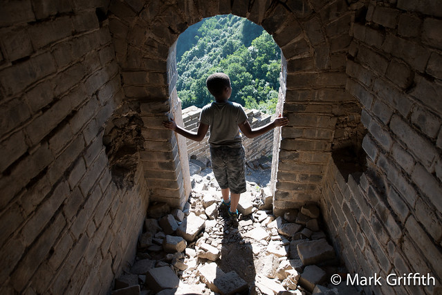
Saturday was the last full day that Seth and Josh had in Beijing so we had to cram in some sight seeing. We woke at 3:45 am and drove out to Huairou and the Great Wall at Jiankou. We arrived as the fog was burning off and parked on the muddy road at the JianKou (Notch of the Bow) parking lot and hiked up to the Wall. I had drug Sofi and Miles along and we opted for the most scrambly section of the Wall that led south west to ZhengBeiLou tower. Miles and Sofi did great scrambling up the cliffs and steep sections of the Wall. I love this portion of the Wall, its ruggedness keeps most people away and there are several amazing towers and cliff sections where you crawl through rocks and narrow points to enter towers. Finally a short 2 and half hours later we arrived at the large ZhengBeiLou tower where we took a quick break before heading down the trail that led back to the road. I gave Seth my pack and I ran down the trail and up the road to the car where I drove it back down to pick everyone up. We drove back to Beijing and showered quickly and drove to DinTaifung for lunch (amazing dumplings), then set off to Yashow market where Josh and Seth got new prescription glasses (around $60 US). Seth and I made a mad dash in the van across town for the Forbidden City where we purchased tickets at 3:45, 15 minutes before they stopped selling them. We did a quick tour through the Forbidden City before they closed at 5pm and then got stuck in traffic for 45 minutes making our way back across town to Chef Too where we met everyone for a celebratory steak dinner.
The next day I drove Seth and Josh to the airport where they met Zhang Chao for their flight back to Seattle. (Zhang Chao was immigrating to the US to work for Amazon). We’d had a great adventure in the back country of south-western China.
Stats
- Total miles by plane : 1300
- Total miles in the car : 500
- Total hours in the car : 27 hours
- Total miles hiked : 30
- Total elevation : 15,280 vertical feet
- Total miles by horse : 1.5 miles
- Seth traveled 7556 miles to get to Yubeng from Bozeman (7300 miles by air, 250 by car and 6 by hiking)
Photos
| www.flickr.com
|
oh my………… what a beautiful trip and a wonderful story you told. I have really enjoyed your stay in China. I learned much and loved hearing you version. Hope to see you when you get back. Love Aunt Marcia
Great read, has China finally helped with using public bathrooms now in the states? 🙂
Public bathrooms in the US are in some ways better (cleaner and don’t smell) but also still worse, in the US doors are 18 inches to 2 feet off floor, doors to bathrooms with 1/2 inch gaps where as China doors go to within 2 inches of floor and there are no gaps in doors. Though there are also the super country bathrooms with no doors, just a hole and no water. 😉
Mark! I loved reading your entry about the wonderful adventure/Mancation you had! Congrats on a great outlook and discovering all the beauty despite the days of rain. 🙂
If your from Washington you have to be able to be happy in the rain. 😉
A rhody forest….BO stages….who knew! Your stories are so well written..
I’d never have guessed there was such a Rhody forest but it was amazing!
Great write up Mark. The photos are beautiful and I’m very jealous of the cooler weather (not the rain and cold though) you were experiencing while the kids and I were dying of heat in HK. It’s so great that Josh, Seth and Ramon were able to see those sites with you and Chao. There is one link that you have highlighted that didn’t take me to the right site, it’s for the yakbutterinn.com. You might want to check it out. It’s a great blog post, of course. You put in so much detail and I love that.
Thanks. 🙂 Yakbutterinn is the planned website that Monica and her brother have, it doesn’t appear to be live, perhaps it never will but I’ll leave the link in and hopefully they’ll get it built one of these days.
Talking about getting away from it all!
“Our driver sighed in relief” Just the driver sighed eh? 😉 We had a similar experience in India. I was ready to grab the wheel the entire time. I definitely sighed.
Thanks so much for sharing all of this Mark. I love learning all of this by living vicariously through you. What an amazing journey. As always, your photos are awesome. I really love the portrait photos you took – such character in those faces!
Thanks Heather, I’d love to see photos and stories from your Europe trip. 😉
Outstanding, Mark! Your pictures paint such a picture and your writing fills in the context. It is fascinating to think this is the world we all share. I don’t mean that to sound sappy, but what a contrast to the day I spent in a Bellevue high-rise working on software. Thanks for adding to my day 🙂
Thanks Carl, surreality abounds all over. Going from Beijing to this back woods location was an awesome experience. Another surreal experience is that living in China is no longer strange but normal and I am interested to see what its like coming back to Seattle.
Believe it or not, I left my nice camera at home and tried very hard to stay off my phone camera. As you can imagine there were about 54 other people who each had a camera following each other like lemmings along the journey so I suspect I’ll just reshare their pics at some stage of the game! 🙂